
Please note that this hike has been cancelled for 11/8. Look for it to be rescheduled in the next few weeks.
****************************************************************************************************
We will hike the whole length of the Sussex Branch Trail on
Saturday Nov 08, 2014. That is 19 miles. Despite the length it
actually is a fairly easy hike: It is a “railtrail” (abandoned
railroad, mostly well maintained, flat). Last time we hiked it it
took us 6:50. We will hike it from the northern end in Branchville,
NJ to the southern end on the trailhead in Allamuchy State Park on
CR 604 (Waterloo Road).
On Sat. Nov. 08, 2014, sunrise will be 6:37, sunset will be 4:48 p.m.
To make sure we have enough time we will meet at 8:00 a.m.
at the Allamuchy trailhead on CR 604, leave as many cars there as
practical, drive to Branchville, and hike back. If there are enough
cars we will leave some at intermediate points, as rescue cars or
as planned ends for people who want a shorter hike.
Directions to the trailhead on CR 604 (Waterloo Road):
From I-80 take Rte 206 north. Make a left on CR 604 (traffic light).
The trailhead is on your right in about 1.0 or 1.1 miles.
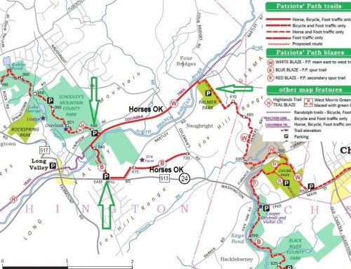
The Sussex Branch Trail and the Paulinskill Valley Trail are NJ
State parks. More information, and some maps, can be found on
http://www.pvtc-kvsp.org/Directions.html and
http://www.njskylands.com/pkkitt , (and more websites).
The Liberty Water Gap Trail uses both the Sussex Branch Trail and
the Paulinskill Valley Trail. The best maps can be found on
http://www.libertygap.org . (No maps will be needed.)
Let one of us know if you plan to participate.
Teun Ott
teun@teunisott.com
908-879-5374 (Home)
908-655-7772 (Cell)
Brian Coan
bcoan@appcomsci.com
908-748-2076 (Work)
862-222-6471 (Cell)